white lettering on orange background northshorevisitor.com com logo
Search
Close this search box.
Search
Close this search box.
waterfalls north shore

North shore waterfalls

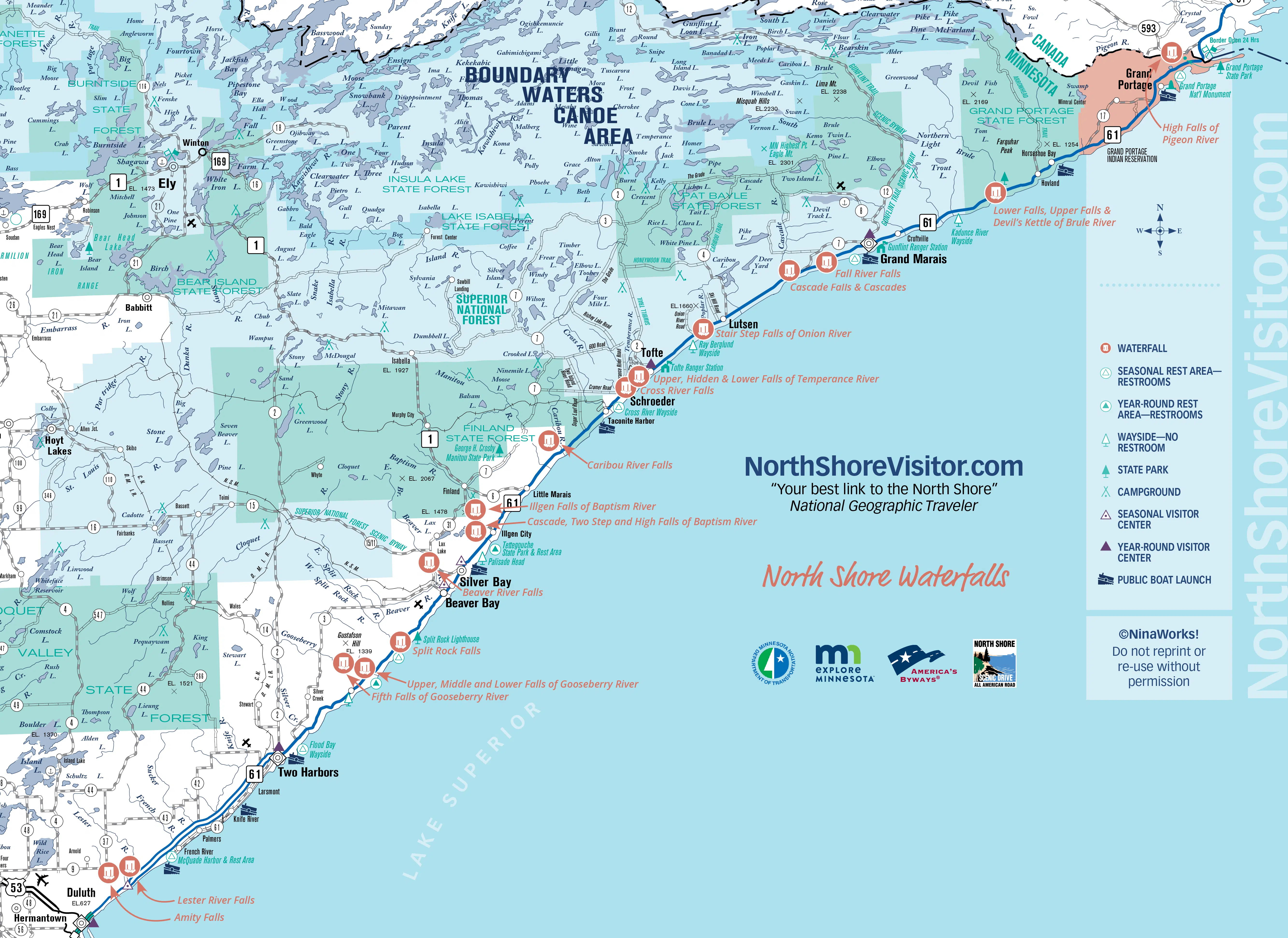
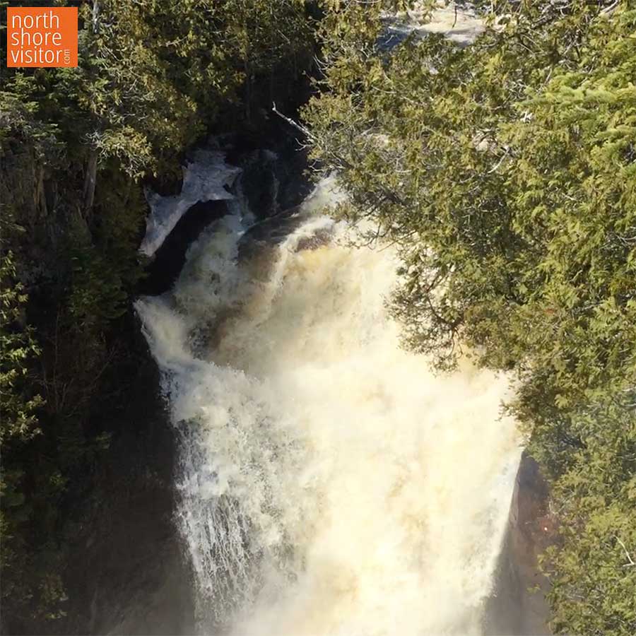
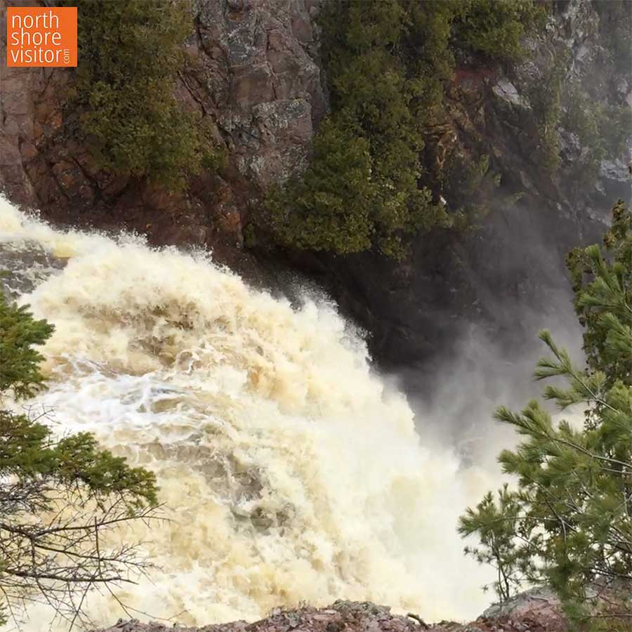
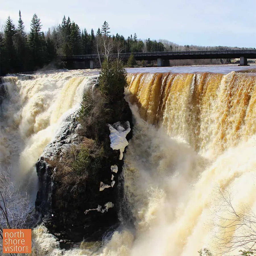
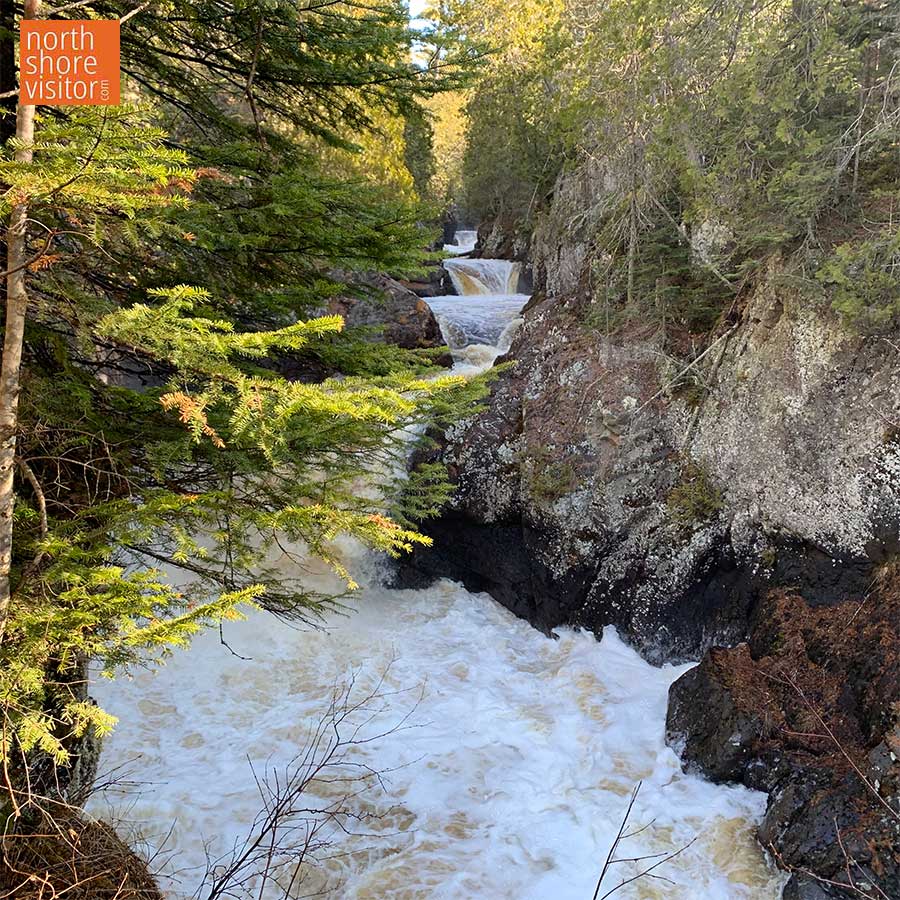
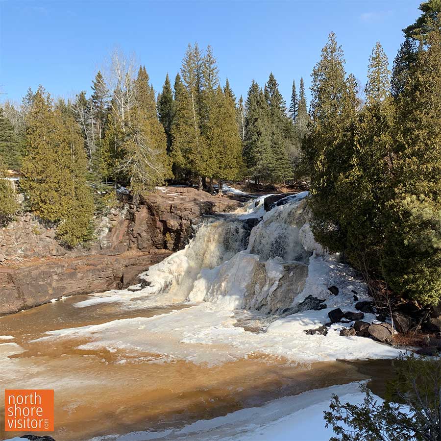
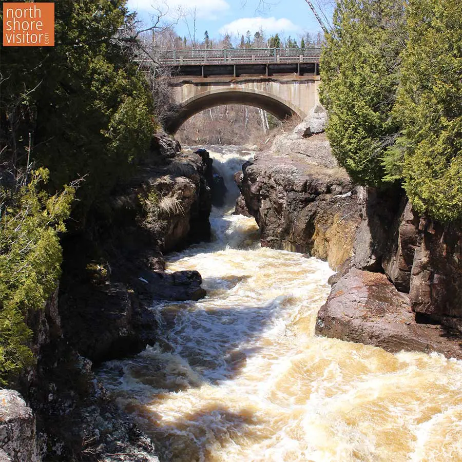
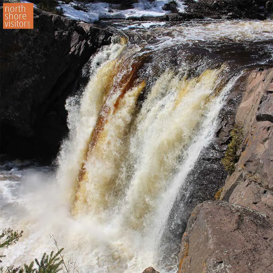
This territory is striped with rivers that make fabulous leaps off- fir-lined ridges. By virtue of motion, rivers change every moment and every season. In 1930 Congress prohibited the construction of dams in St. Louis, Lake and Cook counties, ensuring these rivers remain in their natural state. The average gradient of the rivers is 50-100 feet per mile with waterfalls and rapids sections dropping up to 300 feet per mile.

Along the southwest half of the North Shore, streams tend to be showy. With no headwaters [lakes or other streams that are the water source] , the rivers swell and pound during spring run-off and heavy rains and run low during dry times. They can carry up to four times as much water as those with headwaters. From the Manitou River northeast, the rivers have lakes feeding into them and thus, a more stable flow. But it’s a close call to the best performance during the run-off.

Check out the falls in the Beaver River, in Beaver Bay [MM 51.3].

what is the highest waterfall on the North Shore?

The 120-foot High Falls at Grand Portage State Park is the highest [picture aboved]. It is located on the Pigeon River, part of the international boundary with Canada. The highest falls entirely within Minnesota is the 70-foot High Falls of the Baptism River and is part of Tettegouche State Park.

North Shore Waterfall Maps

North Shore Waterfall Tours

These categories will help you choose.

Spring Beauties
While they are all spring beauties, these waterfalls ONLY rush and roar in the spring.

All Summer Long
With headwaters feeding these rivers, you will find running waterfalls all summer long.

Drive-bys and Short Hikes
Those you can literally drive by or walk to very easily in under a half-mile total.

Big Hike, Big Reward
If you’re willing to take a hike that usually involves some sort of climbing on the way up and descending on the way back, your reward are these waterfalls. Hikes are 1-mile and longer.

High Falls
These waterfalls range from 35 to 120-feet tall.

find waterfalls near me and by type

north shore waterfalls

Select your attributes to find the right waterfall option. After selecting, close this box and your results will appear.

Waterfall type

near

search tips

On mobile, click on the location icon.
On desktop, type in your location.
To find Gunflint Trail shopping, type in ‘Poplar Lake West Cook, MN.’

<\/span>
mile 5.0

Lester Park offers playgrounds, green space, waterfalls, hiking, biking, plus fat bike trails and cross country-ski trails. Playground and the trailhead are located near the parking area of the Lester River Road. See the Amity Falls under hiking and waterfalls for another trailhead.

Start your waterfall tour with a look-see over the Superior Street bridge at the Lester River Falls or park in the lot on the east side of the river, half a block north, and walk the creek-side trail. The northeast trail is a woodland walk with a series of small falls. Best seen during spring run-off.

Walks and hikes range from 0.2 to 9+ miles. Bike Trails include the easy/beginner-friendly 3.7 mile Lester River Trail and the moderate 3.9 mile East & West Amity Trail. Note the Lester River Trail connects to the 43+ mile Duluth Traverse Trail which runs east-to-west across Duluth.

Amenities: restrooms, water, picnic tables, grills and playground at trailhead
Length: 9+ miles
Difficulty
: easy

mile 5.0

Amity Creek runs through Lester Park and you have two options to reach the narrow, picturesque Amity Falls. For a longer hike begin at the Lester Park parking area and hike a 1.5-miles to the northwest where you will come upon the base of the falls, my favorite view. Hike the short steep hill to cross the foot bridge and see the upper river view. To make this a short easy hike, drive north on Occidental Boulevard to the parking area and follow the path to the footbridge. It’s worth it to walk down the hill – and back up – to see the falls from below.

Amenities: restrooms, water, picnic tables, grills and playground at trailhead
Length: from 0.5- to 3+ miles
Difficulty: easy

mile 39.0

It’s a 4-for-1 waterfall stop at Gooseberry Falls State Park! Paved, accessible trails lead 1/10 mile from the visitor center to the most photographed of the falls, the expansive Middle Falls. The paved trails continue north under Highway 61 to a lovely view of the scenic Upper Falls. This wonderful little loop is a half mile total from the visitor center and back. The Riverview Trail heads south from the Middle Falls past the Lower Falls to the mouth of the Gooseberry River and Lake Superior. See the Fifth Falls entry for details on that hike. While quite spectacular during spring runoff, this quick-stop leg-stretcher is a must do on your North Shore visit.

Amenities: Visitor center has restrooms, and during open hours a gift shop and exhibits
Length: 0.3-1.4 miles
Difficulty: easy, paved, accessible to Middle Falls

mile 39.0

While the fifth falls is the smallest waterfall at Gooseberry Falls State Park, it is a nice walk through the woods through the woods. The Fifth Falls Trail runs north along the east side of the meandering river slowly climbing to the base of the falls. The path leads up across the river to a nice scenic overlook before returning south, and downhill, along the west side of the river in a mile loop. In the winter, a there-and-back cross-country ski trail leads to the same falls and scenic overlook.

Amenities: Visitor center has restrooms, and during open hours a gift shop and exhibits
Length: 2+ miles
Difficulty: easy, partially paved

mile 43.4

The Split Rock River waterfalls feels like you’re really out in the woods, but you can be there and back in a half hour. The hike starts on the west side of the river climbing a half-mile through birch forests to the falls tumbling 20 feet over grey rock into a rock-edged pool. You can turn around here [1+ mile total] or hike another three-quarter mile to an impressive red rock [rhyolite] gorge with 50-foot cliffs and twin red pillars. This is another point where you can turn around [2.6 mile total]. If you choose to continue you will see a few more waterfalls over the next 3/4 of a mile. At that point you have to cross the river [in the water] and pick up the high east trail which showcases wide open Lake Superior views.

Highlights: now two hikes, one up each side of the river, with the option of crossing during low water [most of the summer – but can flow after rains] to make it a loop; the west side trail runs above the river past rock cliffs, and on the east side you get river valley views and Lake Superior overlooks
Amenities: at state park 1 mile away
Length: 5 miles round-trip
Difficulty: moderate to more difficult [some steep grades]
Surface: hard pack with roots and rocks

skaters on ice rink in front of gunflint lodge
mile 51.3
beaver bay silver bay north shore mn

Beaver River Falls

The river drops 300 feet in a series of cascades and falls above the Highway 61 bridge, then enters the sedate Beaver Bay. A wayside rest is located on the northwest corner of the bridge. It is a few steps to front-and-center views from the pedestrian walkway on the north side of Highway 61. Don’t want to stop? At least look out the window. This is one of to drive-by waterfalls on the North Shore.

Amenities: restrooms, picnic tables, shops nearby

mile 58.7

The Baptism River has three waterfalls — including the highest entirely within Minnesota at about 70 feet — and three different trails. All three rush and roar during spring snowmelt and make for scenic hikes throughout the summer and autumn. The main trail is semi-strenuous uphill climb with lots of stairs. Just as you wondering if you are there yet, a tenth-mile spur trail brings a little relief and scenery at the attractive Two Step Falls. Carry on the final leg to king daddy High Falls which can be viewed from below [shown here], up top and via a swing bridge over the river. This 3-mile hike is all downhill on the way back.

Options to the High Falls:

  1. from the Superior Hiking Trail on MN Hwy 1; this trail is much flatter and half the distance. Very limited parking however.
  2. drive through park to Trailhead parking; 1.5 mile round trip, hike northto intersection with Superior Hiking Trail, follow it east/right

A great leg stretcher is the 2-mile there-and-back trail from the Visitor Center to Cascade Falls (smallest of the 3 waterfalls).

The High Falls bridge is CLOSED indefinitely due to flood damage. Superior Hiking Trail thru-hikers will have to detour down toward the park office to cross the river on the park road bridge. Note - you can still hike to the High Falls from both sides; you just can't cross the river. The Cascade Falls Trail is also CLOSED indefinitely due to flood damage on a bridge. There is no detour.

Amenities: picnic areas, visitor center
Length: 1.5 – 3.0 miles
Difficulty: easy, to moderate due to stairs

mile 59.4

One of the shortest walks to a North Shore waterfall. This 40-foot beauty tumbles over a huge pine-topped rock ledge. During snow melt in the spring, and after rains, the falls spread wide across the entire ledge while the rest of the year it flows nonstop down the center. Limited [3-4 car] parking at pull-off on MN Hwy 1 [other parking is exclusively for cabin rental].

Length: 0.2 miles
Difficulty: easy

mile 70.7

Caribou Falls is one of the most picturesque waterfalls on the shore, in part because of the approach. From the wayside rest follow the spur trail [at the first bench, continue to follow the spur]. The trail climbs about 100-feet in a half mile before making a 90-degree turn to multiple flights of stairs [~150 in all]. A right hand turn after the first few flights opens to a cedar- and pine-framed view of the falls. It becomes more and more impressive as you get closer, and the gray basalt outcroppings are a striking frame to this 35-foot falls.

Length: 1.2 miles
Difficulty: easy; moderate due to stairs

mile 79.0
cross river falls schroeder mn from hwy 61

Cross River Falls

You can’t miss this classic falls, Highway 61 rolls right by! Take advantage of handy pedestrian bridges for excellent vantage points of the 100′ falls as they roll down and under the roadway before making the final drop on the south side of the bridge.

Amenities: restrooms, picnic tables, shops nearby

hotel room with fireplace in Grand Marais on Lake Superior
mile 80.6

Temperance River has carved out some stunning gorges over which flow the Upper Falls, Hidden Falls, and Lower Cascades. To watch the Lower Cascades tumble into Lake Superior, follow the short easy loop on the lakeside of the highway [.25 mile total].

Tucked deep into the narrow gap, the river dives into a pool just above the roadside parking. Get a peek there before ascending stone steps to the cliffside overlook [not necessarily family-friendly]. The trail continues riverside over smooth rock outcroppings and through cedar stands to the High Falls. Less than 2 miles for all three waterfalls.

Amenities: restrooms in the campground, small state park visitor center store
Length
: 0.25 to 2+ miles
Difficulty: easy to moderate

mile 86.6

Climb the wooden steps and hike above the river to view the cascades near the river mouth then continue another 1/2 mile to see the Stair Step Falls. Can only be seen before the trees leaf out and is best in spring when the river rushes. Easy to follow trail from parking at the Ray Berglund Wayside and Recreation Site.

Length: 1.15 miles
Difficulty: easy

mile 99.8

Ten miles above Highway 61 Cascade River begins its descent to Lake Superior. Dropping 900 feet in the lower three miles, the river takes a steep final run in the last quarter mile as it drops 120 feet through a deep, churning gorge. See the Cascade Falls and cascades on an easy loop that includes overlooks and a foot bridge with excellent views of the falls. The loop that includes the falls, cascades and bridge over the river is about 1/2 mile; you can extend your hike on either side of the river.

mile 107.3

The paved Gitchi Gami Bike Trail passes directly in front of the falls of the Fall River. Bike or walk a 2.6 miles west from downtown Grand Marais or 2.6 miles east from Cut Face Wayside. Features pretty rock cuts and views of the river mouth in Lake Superior.

Length: 5.1 miles of trail one-way
Difficulty: moderate due to steep hill on west side of Grand Marais

mile 124.0

Judge Magney State Park’s claim to fame is the Devil’s Kettle. Rumored to have no bottom this watery cauldron perpetually turns and froths. The hike up treats you to excellent vantage points of the Lower Falls before leading to where the river course splits. About half of the river’s water flow runs over the grand Upper Falls while the other disappears into the Devil’s Kettle. The river rushes in the spring, but to get the best perspective of the Devil’s kettle, plan a summer or autumn visit. Plan on 100+ stairs each way; about 2 ¼ miles total.

sun over gunflint trail lake at golden eagle cabins
mile 150.3

On the US/Canadian border, the Pigeon River drops 950 feet ending with the 120-foot drop High Falls, the highest you will find on the North Shore. This lower reach is particularly rugged until a short distance after the falls, where the river widens. An easy half-mile trail in Grand Portage State Park leads to the High Falls. The trail ends with two great viewing decks where you can feel the spray of the falls!

mile 188.7
kakabeka falls ontario canada

Kakabeka Falls of Kaministiquia River

Wrap up your waterfall tour in Canada at the spectacular 40-meter/131-foot “Niagara of the North” which drops precipitously into a rock-walled canyon. Kakabeka Falls Provincial Park is located in Ontario, Canada – you will need a passport to enter Canada/return to the USA.

sparkling wintry lake superior and ice sheets stacked on north shore

Get North Shore travel tips delivered to your inbox